Earthwise and Eagle Plains Intersect Gold Mineralization in all Holes at the Iron Range Precious Metals Project, SE BC
Earthwise Intersects 60.5 Metres Grading 0.76 g/t Gold, Including 1.0 Metre Grading 6.62 g/t Gold at Iron Range
Press Release Disclaimer: This is a press release distributed through the XPR Media network. It has not been independently verified by our newsroom.


Earthwise Intersects 60.5 Metres Grading 0.76 g/t Gold, Including 1.0 Metre Grading 6.62 g/t Gold at Iron Range
VANCOUVER, BC / ACCESS Newswire / September 2, 2026 / Earthwise Minerals Corp. (CSE:WISE)(FSE:966)(OTCQB:EWISF) (“Earthwise” or the “Company“) is pleased to announce assay results from the 2026 diamond drill program at the Iron Range Gold Project in southeastern British Columbia. The three-hole, 1,182-metre program intersected gold mineralization in all three holes, highlighted by 60.5 metres grading 0.76 g/t gold in drill hole IR26055, including 1.0 metre grading 6.62 g/t gold. Earthwise holds the exclusive option to earn up to an 80% interest in the Iron Range Gold Project from Eagle Plains Resources (TSX-V:EPL) (OTCQB:EGPLF) (“EPL” or “Eagle Plains”).
Highlights:
-
All three holes intersected mineralization
-
IR26053: 15m @ 0.53g/t Au; and 0.50m @ 7.26 g/t Au;
-
IR26054: 24m @ 0.73 g/t Au; and 0.5m @ 11.75 g/t Au;
-
IR26055: 60.5m @ 0.76 g/t Au; including 1.0m @ 6.62 g/t Au;
-
Potential for multiple ore shoots within Talon Zone;
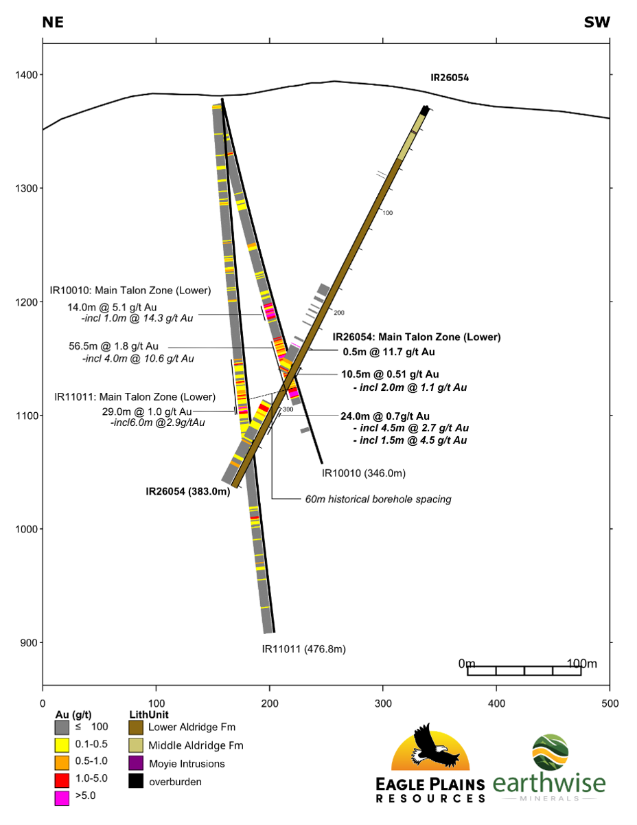
The 2026 drill program was designed to infill historical mineralized intercepts and assess continuity of mineralization along trend at the Talon Zone structure, where 2010 drilling by Eagle Plains intersected 2 intervals of strong and continuous mineralization including 14.0m grading 5.1g/t gold, 1.86% lead, 2.1% Zinc, 75.3g/t silver and 7.1m grading 8.13g/t gold, 2.84% lead, 3.07% zinc, 86.6g/t silver (DDH IR10010).
The 20,021ha Iron Range Project is considered by management of both Eagle Plains and Earthwise to hold excellent potential for the presence of structurally controlled gold-silver mineralization, iron-oxide copper-gold (“IOCG”) and Sullivan-style lead-zinc-silver sedimentary-exhalative (“sedex”) mineralization. The drill program was managed by Terralogic Exploration Inc. and diamond drilling was contracted to QB Drilling.
Mark Luchinski, Chief Executive Officer of Earthwise Minerals, commented:
“We are very pleased with these results, which confirm continuity of gold mineralization between historical drill holes and strengthen the geological case for the Talon Zone. Importantly, drilling has tested less than 10% of the broader multi-element soil geochemical anomaly, while the coincident IP chargeability and resistivity anomaly remains open to the southwest and north. With the vast majority of the broader anomaly still untested, we believe there is significant exploration potential remaining at the Talon Zone.”
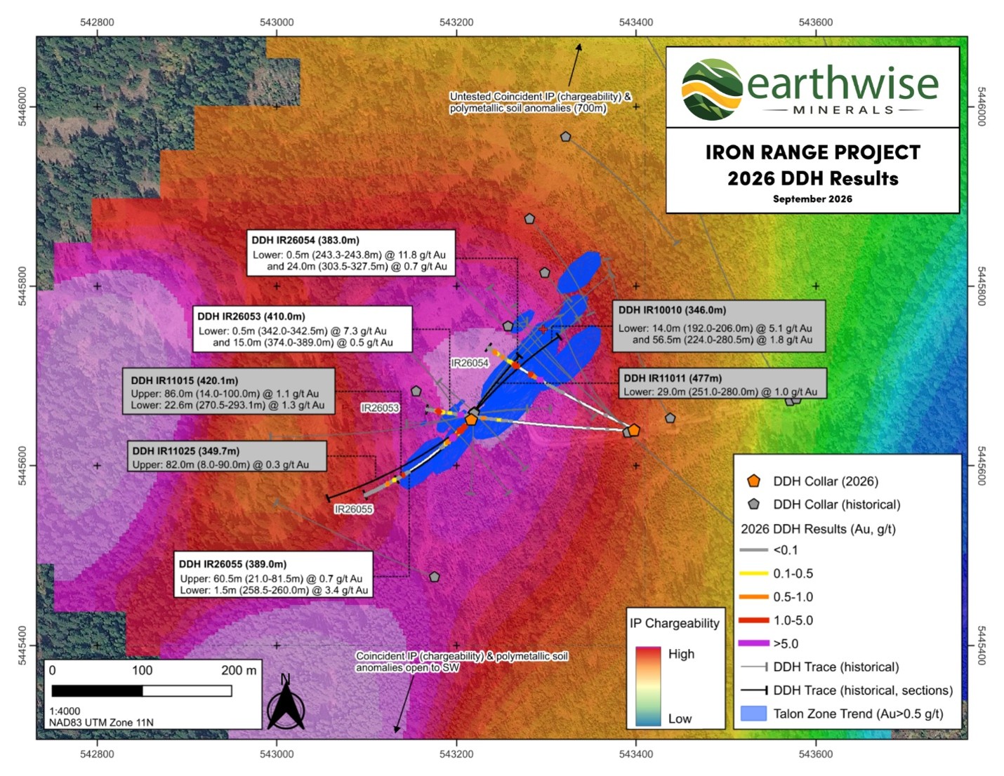
Table 1 Drill Hole Information:
|
Hole ID |
Easting* |
Northing* |
Elev. (m) |
Az. (°) |
Incl. (°) |
Length (m) |
|
IR26053 |
543397 |
5445640 |
1371 |
270 |
-56 |
410 |
|
IR26054 |
543398 |
5445641 |
1371 |
295 |
-61 |
383 |
|
IR26055 |
543216 |
5445651 |
1369 |
223 |
-67 |
389 |
|
TOTAL |
1182 |
|||||
*Collar locations projected in NAD83 UTM Zone 11N
2026 Drill Results
Table 2 Analytical Results:
|
Hole ID |
From (m) |
To (m) |
Int (m)* |
Ag (g/t) |
Au (g/t) |
Pb (%) |
Zn (%) |
|
|
IR26053 |
296.00 |
297.00 |
1.00 |
12.10 |
0.55 |
0.31 |
0.89 |
|
|
and |
318.00 |
319.00 |
1.00 |
13.57 |
0.94 |
0.52 |
0.73 |
|
|
incl |
318.00 |
318.50 |
0.50 |
26.80 |
1.88 |
1.04 |
1.45 |
|
|
and |
338.50 |
398.00 |
59.50 |
6.92 |
0.26 |
0.05 |
0.13 |
|
|
incl |
338.50 |
342.50 |
4.00 |
7.68 |
1.03 |
0.08 |
0.10 |
|
|
incl |
342.00 |
342.50 |
0.50 |
49.90 |
7.26 |
0.67 |
0.81 |
|
|
and |
374.00 |
389.00 |
15.00 |
1.65 |
0.53 |
0.09 |
0.21 |
|
|
incl |
386.00 |
389.00 |
3.00 |
3.02 |
0.90 |
0.08 |
0.17 |
|
|
incl |
386.00 |
387.50 |
1.50 |
3.45 |
1.08 |
0.13 |
0.32 |
|
|
IR26054 |
243.25 |
243.75 |
0.50 |
79.90 |
11.75 |
3.20 |
0.02 |
|
|
and |
258.50 |
269.00 |
10.50 |
0.99 |
0.51 |
0.01 |
0.01 |
|
|
incl |
267.00 |
269.00 |
2.00 |
0.49 |
1.11 |
0.00 |
0.00 |
|
|
incl |
267.00 |
268.00 |
1.00 |
0.89 |
1.42 |
0.00 |
0.00 |
|
|
and |
303.50 |
327.50 |
24.00 |
5.42 |
0.73 |
0.18 |
0.25 |
|
|
incl |
305.00 |
309.50 |
4.50 |
4.63 |
2.73 |
0.08 |
0.06 |
|
|
incl |
305.00 |
306.50 |
1.50 |
8.15 |
4.47 |
0.18 |
0.17 |
|
|
and |
362.90 |
365.70 |
2.80 |
0.84 |
0.55 |
0.01 |
0.01 |
|
|
IR26055 |
19.50 |
104.00 |
84.50 |
4.33 |
0.60 |
0.08 |
0.12 |
|
|
incl |
21.00 |
81.50 |
60.50 |
4.58 |
0.76 |
0.09 |
0.14 |
|
|
incl |
27.00 |
29.00 |
2.00 |
18.34 |
1.40 |
0.03 |
0.05 |
|
|
and incl |
41.00 |
47.50 |
6.50 |
4.42 |
1.43 |
0.03 |
0.07 |
|
|
incl |
44.50 |
45.50 |
1.00 |
21.31 |
3.40 |
0.08 |
0.12 |
|
|
and incl |
72.20 |
80.00 |
7.80 |
13.10 |
2.22 |
0.46 |
0.46 |
|
|
incl |
72.20 |
73.70 |
1.50 |
7.67 |
3.67 |
0.04 |
0.37 |
|
|
and incl |
76.20 |
78.20 |
2.00 |
35.37 |
4.08 |
1.20 |
0.81 |
|
|
incl |
77.20 |
78.20 |
1.00 |
67.10 |
6.62 |
2.11 |
1.13 |
|
|
and |
258.50 |
260.00 |
1.50 |
1.82 |
3.09 |
0.01 |
0.01 |
* All drill indicated intercepts as reported in this news release are measured along core length and true thickness is yet to be determined.
All drillholes collared in Middle Aldridge and ended in Lower Aldridge Formation sediments, typical of the Purcell Basin turbidite stratigraphy. Talon Zone style mineralization is defined by strong silica-feldspar alteration associated with chaotic quartz-feldspar-ankerite veins. Polymetallic mineralization (pyrrhotite-pyrite-sphalerite-galena-arsenopyrite-sulfosalts) is typical throughout the structural zone as veins, fracture infill and localized breccia cement. The Talon Zone structure is interpreted to be a NE-SW trending structural splay off the regional Iron Range Fault and is marked by a multi element soil geochemical anomaly and coincident geophysical Induced Polarization (IP) chargeability and resistivity anomalies. The IP chargeability + resistivity anomaly remains open to the southwest and north and drilling has only tested <10% of the broader multi element soil geochemical anomaly.
Chuck Downie, President and CEO of Eagle Plains commented: “We are very encouraged by the results from the 2026 drilling program. Hole IR26055 indicates the potential for additional ore shoots within the broader Talon Zone. Similar structural splays off of the Iron Range Fault system, coincident with anomalous pathfinder geochemistry and IP geophysical anomalies that are modelled to extend to depth exist elsewhere in the Talon Zone area and are untested by drilling.”
DDH IR26053 was designed to cross-cut the Talon Zone structure, infilling historical holes IR11011 and IR11015. At target depth the boreholes are spaced approximately 120m along trend. IR26053 successfully infilled the historical drilling, piercing target stratigraphy ~70m NE of IR11015 and ~50m SW of IR11011. Geochemical results defined a number of anomalous zones of gold mineralization, confirming continuity of gold mineralization between historical holes. The interval from 342.0 – 342.5 returned 7.26 g/t Au and 49.9 g/t Ag, associated with semi-massive pyrrhotite veining in weakly altered Aldridge sediments. Interval 374.0 – 389.0 returned 0.53 g/t Au over 15m and is associated with intense, pervasive silica and feldspar alteration of Aldridge sediments that is typical of mineralized stratigraphy within the main (lower) Talon Zone.
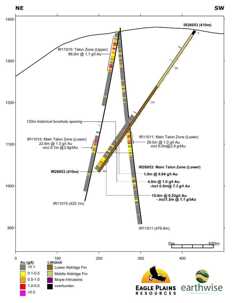
DDH IR26054 was designed to cross-cut the Talon Zone structure, infilling between historical holes IR10010 and IR11011. At target depth the boreholes are spaced approximately 60m along trend. IR26054 successfully infilled the historical drilling, piercing target stratigraphy ~ 30m NE of IR11011 and ~30m SW of IR10010. An interval of well developed pyrrhotite veining in weakly altered Aldridge sediments returned 11.75 g/t Au and 79.9 g/t Ag over 0.5m from 243.25 – 243.75m. Geochemical results from the main (lower) Talon Zone Structure, intercepted between 258-345m, include 24m at 0.73 g/t Au from 303.5 – 327.5m. Within this broader interval, 305.0 – 306.5 returned 4.47 g/t Au over 1.5m. Mineralization in the main (lower) Talon Zone horizon is associated with strong, pervasive silica-felspar alteration and chaotic swarms of variably mineralized quartz-feldspar-carbonate veins and lesser breccia cement.
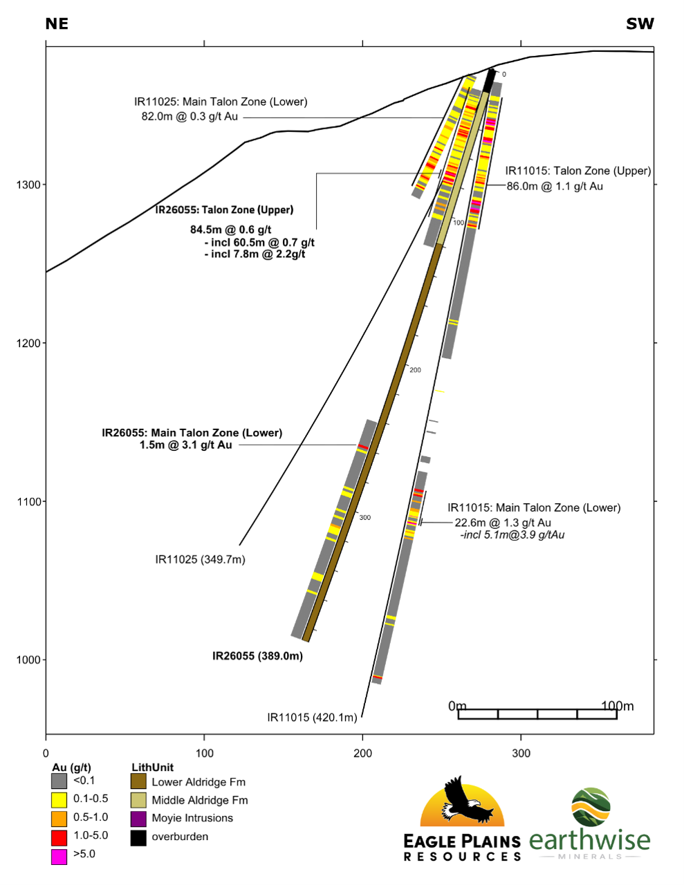
DDH IR26055 was designed to overcut IR11015, assessing continuity of an upper mineralized structural trend to the southwest, an area that is historically underexplored. The hole successfully intercepted an upper and lower mineralized horizon first defined in DDH IR11015. The hole was collared in the upper mineralized horizon (15-104m), where polymetallic mineralization (pyrrhotite-pyrite-sphalerite-galena-arsenopyrite-sulfosalts) is associated with intense oxidization of sulphides and strong silica and feldspar alteration of the Middle Aldridge sediments. The strong-intense alteration associated with polymetallic mineralization is consistent with the mineralization style observed at the main (lower) Talon Zone horizon and could indicate the potential for multiple ore shoots within the broader Talon Zone Structure. Geochemical results from the upper horizon included 60.5m of 0.76 g/t Au from 21.0 – 81.5m. including 1.0m at 6.62 g/t Au and 67.1 g/t Ag from 77.2 – 78.2m.
The main (lower) Talon Zone mineralized horizon was intercepted between 241-380m, a 40m step-out from IR11015. The best results were 3.09 g/t Au over 1.5m from 258.5 – 260.0m.
Quality Assurance and Quality Control
All drill core samples were analyzed at ALS Canada Ltd. in North Vancouver, BC. The sampling program was undertaken by TerraLogic Exploration personnel under the direction of Kerry Bates, P.Geo. QA/QC protocols are maintained through the insertion of certified reference material (standards), blanks and coarse reject duplicates within the sample stream. Drill core is cut in-half with a diamond saw with one-half placed in sealed bags and shipped to the laboratory and the other half retained in permanent core store in Cranbrook, BC. A secure chain of custody is maintained in transporting and storing of all samples.
The entire sample is crushed to 70% passing 2mm (10 mesh), of which a 250g split is pulverized to 80% passing 75 micron (200 mesh). Multi-element analyses were determined by 4-acid digestion followed by Inductively Coupled Plasma Mass Spectrometry (ICP-MS), reporting 48 elements. Samples with >9,500 ppm As, Cu, Zn Pb were further analyzed with Inductively Coupled Plasma – Atomic Emission Spectroscopy (ICP-AES). Samples with > 95ppm Ag were further analyzed with Inductively Coupled Plasma – Atomic Emission Spectroscopy (ICP-AES). Au is determined by fire assay on a 50g split utilizing Atomic Absorption Spectroscopy (AAS). Samples with >9 ppm Au were further analyzed using fire assay fusion with gravimetric analysis.
Iron Range Project Summary
The 20,021ha Iron Range Project located near Creston, BC, is owned 100% by Eagle Plains, subject to a 1% NSR held by a third party on a portion of the claim group. A well-developed transportation and power corridor transects the southern part of the property, including a high-pressure gas pipeline and a high-voltage hydro-electric line, both of which follow the CPR mainline and Highway 3. The rail line provides efficient access to the Teck smelter in Trail, B.C. The project is fully permitted with a Multi-Year Area Based (MYAB) permit in place issued by the BC Ministry of Mining and Critical Minerals that includes provisions for geophysical work, mechanical trenching, access trail construction and diamond drilling.
The Iron Range property covers an extensive area approximately 10km x 32km which overlies the regional Iron Range Fault System (“IRFS”). Prior to the acquisition by Eagle Plains in 2001, the property had seen little systematic exploration for other than iron resources known to exist on the property since the late 1800s. Since 2001, Eagle Plains and its partners have completed 21,593m of diamond-drilling in 87 holes, collected 2482 line-km of airborne and surface geophysical data and analysed 10,053 soil geochemical samples, 495 rock samples and 6955 drill core samples.
Drilling at Iron Range in 2010 resulted in the discovery of the Talon Zone, where drill-hole IR10-010 intersected 2 intervals of strong and continuous mineralization including 14.0m grading 5.1g/t gold, 1.86% lead, 2.1% Zinc, 75.3g/t silver and 7.1m grading 8.13g/t gold, 2.84% lead, 3.07% zinc, 86.6g/t silver (Eagle Plains news release December 21st, 2010). Previous drilling 10km north of the Talon Zone in 2008 by Eagle Plains intersected gold mineralization in drill-hole IR08006 which assayed 7.0m grading 51.52g/t (1.50 oz/ton) gold (Eagle Plains news release dated April 20th, 2009).
Mineralization at the Pyromorphite Zone (BC MinFile 082FSE141) was discovered in 2009 after construction of logging roads exposed sheared and brecciated sediments hosting cm-scale quartz veins bearing pyromorphite (lead) mineralization. No significant work has been completed at the zone since its initial discovery by the previous tenure holder. Rock (grab) sample SK10-207 reports 27.0 g/t Au, 173.0 g/t Ag, and 13.4% Pb (BC Assessment Report 31659). Rock (grab) sample MK10-170 reports 54.7 g/t Au, 42.2 g/t Ag, and 2.8% Pb (BC Assessment Report 31659). 2025 fieldwork at the Pyromorphite returned up to 13.4 g/t Au, 27.2 g/t Ag, > 10,000 ppm As, and 2.7% Pb from an in situ grab sample. (KBBIRR004) (Eagle Plains news release dated November 17, 2025). The poly-metallic (As-Pb-Zn) nature of the mineralization at the Pyromorphite Zone and the association between arsenopyrite (As) and Au mineralization are consistent with the structurally hosted mineralization that defines the Talon Zone target 12 km to the SW.
Management cautions that historical results were collected and reported by past operators and have not been verified nor confirmed by a Qualified Person but form a basis for ongoing work on the subject properties. Management cautions that past results or discoveries on proximate land are not necessarily indicative of the results that may be achieved on the subject properties.
Rock grab samples are selective samples by nature and as such are not necessarily representative of the mineralization hosted across the property. Some of the above results were taken directly from MINFILE descriptions and assessment reports (ARIS) filed with the BC government. Management cautions that historical results were collected and reported by past operators and have not been verified nor confirmed by a Qualified Person but form a basis for ongoing work on the subject properties. Management cautions that past results or discoveries on proximate land are not necessarily indicative of the results that may be achieved on the subject properties.
Qualified Person
The scientific and technical information contained in this news release has been reviewed and approved by Kerry Bates, P.Geo., a Qualified Person as defined by National Instrument 43-101 – Standards of Disclosure for Mineral Projects. Mr. Bates is the Exploration Manager for Eagle Plains Resources Ltd. and is not independent of the Company.
About Earthwise Minerals
Earthwise Minerals Corp. (CSE: WISE; FSE: 966; OTCQB: EWISF) is a Canadian junior exploration company focused on advancing the Iron Range Gold Project in southeastern British Columbia near Creston, B.C. The Company holds an option to earn up to an 80% interest in the fully permitted project, which is road-accessible and situated within a prolific mineralized corridor. The property covers a 10 km x 32 km area along the Iron Range Fault System and hosts multiple high-grade gold showings and large-scale geophysical and geochemical anomalies.
For more information, visit www.earthwiseminerals.com.
EARTHWISE MINERALS CORP.,
ON BEHALF OF THE BOARD
“Mark Luchinski”
Contact Information:
Mark Luchinski
Chief Executive Officer, Director
Telephone: (604) 506-6201
Email: luch@luchccorp.com
Forward Looking Statements
This news release contains “forward-looking information” within the meaning of applicable Canadian securities laws and may also constitute “forward-looking statements” within the meaning of United States securities laws (collectively, “forward-looking statements”). Forward-looking statements in this release include, but are not limited to, statements regarding the Company’s future plans, exploration programs, development activities, and the potential of its mineral properties.
Forward-looking statements are based on the current expectations, estimates, beliefs and assumptions of management as of the date hereof. Such statements are subject to a number of known and unknown risks, uncertainties and other factors that may cause actual results, performance or achievements of the Company to differ materially from those expressed or implied by such forward-looking statements. These risks and uncertainties include, but are not limited to, risks related to exploration and development activities, commodity prices, market conditions, availability of financing, regulatory approvals, environmental risks, and general economic conditions.
Although the Company believes that the assumptions and expectations reflected in such forward-looking statements are reasonable, there can be no assurance that such statements will prove to be accurate, and actual results and future events could differ materially from those anticipated. Readers are cautioned not to place undue reliance on forward-looking statements.
Forward-looking statements are made as of the date hereof, and the Company undertakes no obligation to update or revise any forward-looking statements, except as required by applicable law.
Historical and Technical Information.
Certain technical and historical information contained in this news release is derived from prior exploration work conducted by third parties. While the Company believes such information to be reliable, it has not independently verified all such information and therefore it should not be relied upon as an indication of current mineral resources or reserves, nor as a guarantee of future exploration results.
U.S. Securities Disclaimer
This news release does not constitute an offer to sell or a solicitation of an offer to buy any securities in the United States. The securities of the Company have not been and will not be registered under the United States Securities Act of 1933, as amended, or any state securities laws, and may not be offered or sold within the United States or to, or for the account or benefit of, U.S. persons absent registration or an applicable exemption from such registration requirements.
Exchange Disclaimer
The Canadian Securities Exchange has not reviewed and does not accept responsibility for the adequacy or accuracy of this news release.
For more information, please contact Mark Luchinski, Chief Executive Officer and Director, at luch@luchccorp.com or (604) 506-6201.
SOURCE: Earthwise Minerals Corp.
View the original press release on ACCESS Newswire
Media gallery